You should be reading the material in Wallace and Hobbs in Chapter 7 up to and including the material on Geostrphic Wind (pp. 271 to 282).
The following internet sources have some additional graphics that are useful for understanding vorticity and divergence patterns:
An Online Vorticity and Divergence Lecture
Terms:
Relative Vorticity: Vertical component of rotation of the air flow at a point. (This is rotation in the horizontal plane.)
Earth's Rotation Component: Vertical component of the earth's rotation vector at a point. This is the Coriolis Parameter.
Note: in physics, the rotation vector can be thought of as the "axle" of rotation. Use the "right hand rule" to determine the direction of the vector.
Absolute Vorticity: Relative vorticity plus the earth's rotation component at a point.
What is usually plotted on the weather maps (particularly at 500mb) are contour lines of Absolute Vorticity. The absolute voriticity is often plotted along with the 500mb height contours. This allows the forecaster to easily see the advection of the vorticity by the 500mb geostrophic winds. There are dynamical equations that relate vorticity advection to vertical motion.
Convergence: Negative Divergence is sometimes called convergence.
Horizontal Divergence in the atmosphere can be determined using the component winds. In cartesian coordinates the formula is:
D = (∂u/∂x) + (∂v/∂y)
Note there are two terms: the instantaneous rate of change of the u component of the winds in the x direction, and the instantaneous rate of change of the v component in the y direction.
We can estimate the value of the divergence by using a centered differencing approach, where:
D = (Δu/Δx) + (Δv/Δy)
The forumula for the "horizontal" vorticity in cartesian coordinates is similar (again note that this is the vertical component of the rotation vector):
ζ = (∂v/∂x) - (∂u/∂y)
Examples of using these formula for simple calculations are given in the instructions for the worksheet.
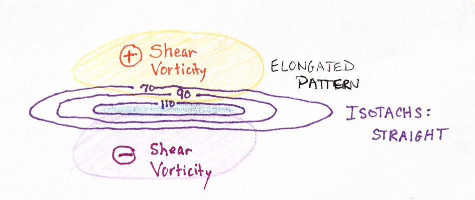
When we look at the 500mb chart, there will often be vorticity maxima associated with straight flow. This vorticity is shear vorticity. In the following example, the contour lines are isotachs:
Shear vorticity maxima are typically elongated.
With well defined troughs, the vorticity pattern derives from a combination of shear and curvature. For example:
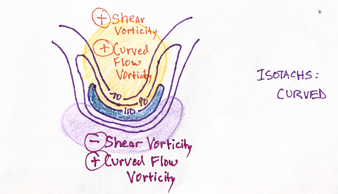
The positive combination of both shear and curvature can result in very strong vorticity maxes.
It can be shown that geostrophic winds are very close to being nondivergent -- in other words, for the geostrphic wind flow, Divergence equals zero.
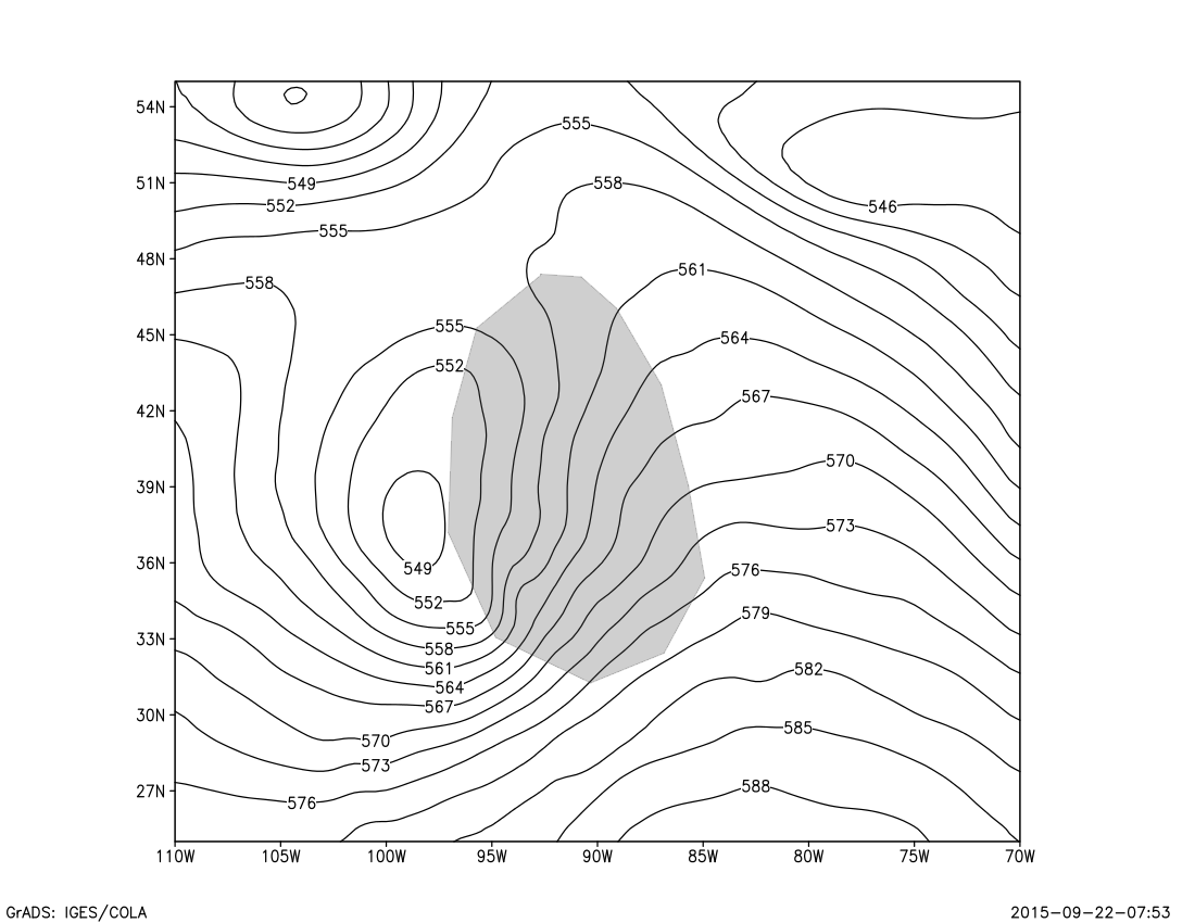
Consider the map below of 500mb heights. The shading shows (approximately) an area where the 500mb height contours are spreading apart (when viewed in the direction of the wind flow). One might think that the divergence in this area would be positive. However, as the wind flow spreads apart, the winds also slow. As a result, the Divergence for the geostrophic winds will be zero. Regions such as this, where the height contours are spreading apart in the direction of the wind flow -- these regions are called diffluent. These are important regions to note on a map. But remember, these regions are not necessarily areas of positive divergence. There may be divergence in this region, but we cannot tell this from the geostrophic winds.
Also note, diffluent regions can also be determined from wind charts, eg: streamlines, wind vectors, etc.
When the height contours are getting closer to each other (in the direction of the wind flow) this is called confluent flow.
Vorticity and Divergence are important attributes of wind flow as they are associated with vertical velocity in the atmosphere. This will be covered in later lectures.