See Vasquez Section 6.8 (starts on Page 119).
This topic is especially relevant to the mid Atlantic region, as we get a lot of winter storms where precipitation types and amounts are hard to forecast.
To begin the forecast process, winter weather systems get the same attention as all other systems, in terms of assessing the various synoptic features. But winter systems have additional important factors that should be considered.
It is especially important to assess the temperatures at various heights above the earth's surface, to determine which layers of the atmosphere are above or below freezing, how thick those layers are, and the potential impact of those layers on precipitation formation and precipitation type.
As your text discusses:
Rain: Forms in a warm layer, or results from melting in a warm layer. Rain or drizzle may form in a layer below freezing as supercooled droplets. Unless there is a frozen nucleus available, moisture condensation between the temperatures of 0C and -10C is usually as supercooled liquid droplets.
Freezing Rain: For this precipitation type, the precipitation must be falling as rain, and freeze on contact. This means there is some warm layer aloft, and it is below freezing at the surface. The layer of cold air near the surface needs to be shallow enough, or close enough to freezing, so the rain does not freeze as it is falling and form sleet.
Sleet: There must be a warm layer present where rain is forming, or where frozen precipitation is melting to rain. Then there needs to be a cold layer sufficiently cold and deep to freeze the rain droplets to ice.
Snow: Snow forms from moisture condensing at cold enough temperatures to accrete as ice. This takes place as various types of crystal growth, depending on temperature. Temperatures less than -10C will almost always result in snow production (vs supercooled droplets). -12C to -16C favors dendrite crystal growth, which is optimal for snow production. The Dendritic Growth Zone (DGZ) is a layer where dendritic snow production is taking place.
Snow forms at -10C to -20C as small crystals. If these initial small ice crystals fall through a supercooled layer of droplets where the temperature is 0C to -10C, the crystals will grow due to accretion onto the existing crystals -- the supercooled droplets will freeze on contact with the ice. Under ideal conditions large and fragile crystals can form (ie, big pretty snowflakes).
A broad range (0C to -20C) of below freezing temperatures in the precipitation producing layer produces the maximum snowfall production.
In general, the 5400 meter contour line of the 1000-to-500mb thickness (the "540 line") will seperate rain and snow at elevations near sea level. For our area, the 0C isotherm at 850mb is also a useful delineator.
These general rules are useful for the first look at the situation, to identify areas that will require further attention. These rules are not particularly useful for detailed analysis.
As your text discusses, the best approach is the top-down method. Determine the layers where preciptation where be forming and note what the temperature of those layers is, and thus the precipitation type. Then determine what layers the preciptation will be falling through.
Frozen preciptation encountering a sufficiently warm layer will melt, and liquid precipitation encountering a sufficiently cold layer will freeze. The rule of thumb is, a layer more than 500 to 1000 ft. (150-300 meters) is sufficiently thick.
If precipitation falls into a dry layer, the layer will be cooled by the evaporation or sublimation of the precipitation. (The phase change from solid to gas is called sublimation.) If this process continues long enough, the layer will be cooled to its wet-bulb temperature. This process lowers the temperature, and raises the dewpoint. (This sort of cooling almost always happens to the near-surface layer to some extent at the onset of precipitation.) A layer of air that is above freezing can possibly be cooled to below freezing after precipitation begins, and change the precipitation type.
The following rules of thumb will typically apply to many winter storms:
-- The heaviest snow is about 150nm to the left of the track of the surface low. The snow is heaviest during the time of the most rapid deepening of the low. The heaviest snowfall occurs ahead of the low by about 300nm.
-- The surface low will move towards, or jump to, the area of greatest pressure falls (useful for nowcasting).
-- The heaviest snow will tend to fall about 90nm to the left of the track of the 850mb low. The -5C isotherm at 850mb will bisect the heavy snow area.
-- The maximum values of precipitable water feeding into the low from the south will often be close to the maximum snowfall amounts (liquid equivalent).
-- The usual rule is 10 inches of snow for every inch of liquid. This would be a 10 to 1 snow to liquid ratio. The actual ratio may vary a lot. Heavy wet (partially melted) snow will have a lower ratio, and dry fluffy snow can have up to a 20 to 1 ratio.
When forecasting winter precipitation, a few of the important factors to consider might be:
-- Look at the overall synoptic situation, and examine the features that are important for all systems: ridges, troughs, vorticity, jets, temperature and moisture advection, etc.
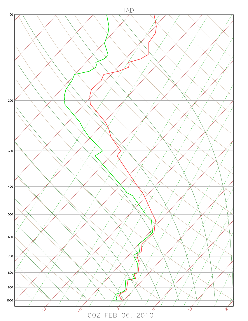
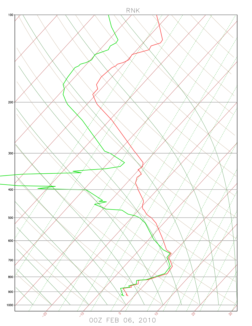
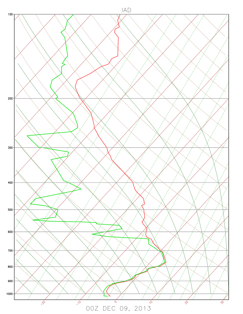
-- In addition, it is necessary to fully understand how the temperatures both at the surface and aloft are going to evolve during the storm. Look at vertical soundings, both observed (RAOB reports) and the model soundings. Especially examine any dry air layers in the obsered soundings that have potential to rapidly cool if precipitation falls through them. These dry layers may not show up on a model sounding, due to resolution limits.
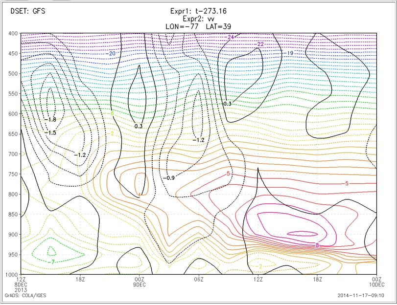
-- Look at horizontal temperature advection in the lower levels to identify levels where warm air may intrude. Examine these areas closely using model-forecast vertical profiles or time-height cross sections. Time-height cross sections of the model forecasts can be very valuable. Look at temperature, to identify warm and cold layers, and to evaluate snow crystal growth potential. Look at relative humidity and vertical velocity, to identify time and vertical level of condensation and precipitation production. Look at time-height cross sections at multiple locations to be sure to fully understand the 4-D picture.
-- An entire winter event may involve many precipitation types. Evaluate the length of time and the intensity for each type. During a snow storm, a few hours of changeover to sleet will reduce snow totals. Warm ground may result in melting, reducing snow totals.
-- Consider time of day; the diurnal cycle may be a source of model error. A model forecast that is marginal for snow vs. rain will more likely result in snow in the early morning hours, and rain in the afternoon.
-- Ice accumulation from freezing rain will depend on how much rain, and it will depend greatly on just how cold it is at the surface. In marginal situations, warm soil can warm the near-surface air and reduce ice accumulations. However, even if it is 0C at shelter height, it may be slightly colder at treetop height. Major ice accumulation on the tops of trees can result in downed limbs and power outages. With cold ground, rain may freeze on contact even if the air temperature is above freezing. Or there may be a very thin layer of sub-freezing air. In this situation, there may be little or no ice accumulation at the tops of tall trees.
-- Look at model forecast of precipitation type. Do not trust it, but understand why the model is forecasting particular precip types (if possible).
-- Think about impact. Even a small amount of snow that sticks, due to very cold ground temperatures, can have a high impact! Ice accumulation from freezing rain can have a high impact. Wind and snow can have a very high impact, even if there is not much snow.
Every storm is different, and must be evaluated for its unique characteristics. Don't depend on the rules of thumb -- they are only a starting point.